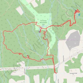
Chaster Falls and Gibsons Creek Falls loop on Elphinstone Mountain
- Distance: 6.3 mi
- Elevation gain: 661 m
- Maximum elevation: 573 m
- Elevation loss: 658 m
- Minimum elevation: 196 m
- Moving time: 2 h 59 m
- Moving speed: 2.1 mph
- Maximum speed: 4.9 mph
- Total time: 3 h 27 m
- Global speed: 1.8 mph
Interactive trail map
Trail profile
- Distance: 6.3 mi
- Elevation gain: 661 m
- Maximum elevation: 573 m
- Elevation loss: 658 m
- Minimum elevation: 196 m
- Moving time: 2 h 59 m
- Moving speed: 2.1 mph
- Maximum speed: 4.9 mph
- Total time: 3 h 27 m
- Global speed: 1.8 mph
About this trail
Name: Chaster Falls and Gibsons Creek Falls loop on Elphinstone Mountain trail, distance, elevation, map, profile, GPS track
Coordinates: 49.41754 -123.54820 49.43164 -123.52234
Other hiking, mountain biking, running and outdoor activity trails
Click on a trail to view its statistics, map and profile.
Loop hike to Chaster Falls
Canada > British Columbia > Sunshine Coast Regional District > Area E (Elphinstone)
Distance: 4.2 mi • Elevation gain: 555 m • Maximum elevation: 645 m