Ein Yorkeam - Tzafir
עין ירקעם ומיצד צפיר: נחל חתירה, מעלה ימין וגב ימין
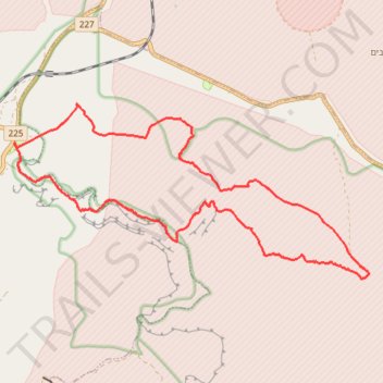
- Distance: 12.3 mi
- Elevation gain: 572 m
- Maximum elevation: 477 m
- Elevation loss: 572 m
- Minimum elevation: 116 m
- Moving time: 5 h 42 m
- Moving speed: 2.1 mph
- Maximum speed: 2.6 mph
- Total time: 5 h 42 m
- Global speed: 2.1 mph
Interactive trail map
Trail profile
- Distance: 12.3 mi
- Elevation gain: 572 m
- Maximum elevation: 477 m
- Elevation loss: 572 m
- Minimum elevation: 116 m
- Moving time: 5 h 42 m
- Moving speed: 2.1 mph
- Maximum speed: 2.6 mph
- Total time: 5 h 42 m
- Global speed: 2.1 mph
About this trail
Name: Ein Yorkeam - Tzafir trail, distance, elevation, map, profile, GPS track
Coordinates: 30.92076 35.03865 30.95055 35.10905
Other hiking, mountain biking, running and outdoor activity trails
Click on a trail to view its statistics, map and profile.
Mashashit and Tzayad Hike
Israel > South District > Ramat Negev Regional Council
ממשית והר צייד: דרך שרידי עיר נבטית ושמורת מצלעות המכתש הגדול
Distance: 20.1 mi • Elevation gain: 775 m • Maximum elevation: 654 m
Akrabim and Tzafir
Israel > South District > Tamar Regional Council
עקרבים וצפיר: על התפר שבין הנגב לערבה: מעלה עקרבים ומעלה צפיר
Distance: 11.4 mi • Elevation gain: 673 m • Maximum elevation: 521 m