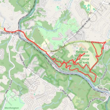
Patapsco Valley State Park - Horse Farm Area
- Distance: 8.1 mi
- Elevation gain: 240 m
- Maximum elevation: 113 m
- Elevation loss: 241 m
- Minimum elevation: 34 m
- Moving time: 1 h 45 m
- Moving speed: 4.6 mph
- Maximum speed: 8.5 mph
- Total time: 1 h 49 m
- Global speed: 4.4 mph
Interactive trail map
Trail profile
- Distance: 8.1 mi
- Elevation gain: 240 m
- Maximum elevation: 113 m
- Elevation loss: 241 m
- Minimum elevation: 34 m
- Moving time: 1 h 45 m
- Moving speed: 4.6 mph
- Maximum speed: 8.5 mph
- Total time: 1 h 49 m
- Global speed: 4.4 mph
About this trail
Name: Patapsco Valley State Park - Horse Farm Area trail, distance, elevation, map, profile, GPS track
Coordinates: 39.25428 -76.79966 39.26858 -76.76502
Other hiking, mountain biking, running and outdoor activity trails
Click on a trail to view its statistics, map and profile.
Old Ellicott City / OEC Connector Trail
United States > Maryland > Howard County > Ellicott City
Distance: 4.2 mi • Elevation gain: 149 m • Maximum elevation: 118 m
Patapsco Valley State Park - Hilton Area Loop Hike
United States > Maryland > Baltimore County > Catonsville
Distance: 4.0 mi • Elevation gain: 182 m • Maximum elevation: 122 m
Patapsco Valley State Park Ilchester Area Loop
United States > Maryland > Howard County > Ilchester
Distance: 5.6 mi • Elevation gain: 315 m • Maximum elevation: 109 m
Patapsco Valley State Park Hilton Area
United States > Maryland > Baltimore County > Catonsville
Distance: 5.5 mi • Elevation gain: 240 m • Maximum elevation: 123 m
Hike through Patapsco Valley State Park Ilchester Area
United States > Maryland > Howard County > Ilchester
Distance: 5.3 mi • Elevation gain: 279 m • Maximum elevation: 108 m
St. Marys's College Ruins and Patapsco Valley State Park Illchester Area hike
United States > Maryland > Howard County > Ilchester
Distance: 3.0 mi • Elevation gain: 152 m • Maximum elevation: 104 m
Crossing Patapsco Valley State Park Ilchester Area
United States > Maryland > Howard County > Ilchester
Morning Hike
Distance: 3.6 mi • Elevation gain: 225 m • Maximum elevation: 110 m
Patapsco Valley State Park Hilton Area Loop
United States > Maryland > Baltimore County > Catonsville
Distance: 6.2 mi • Elevation gain: 251 m • Maximum elevation: 125 m
Patapsco River and Santee Branch Trail loop
United States > Maryland > Baltimore County > Catonsville
Distance: 5.6 mi • Elevation gain: 221 m • Maximum elevation: 123 m
Patapsco Valley State Park Ilchester Area
United States > Maryland > Howard County > Ilchester
Morning Hike
Distance: 4.8 mi • Elevation gain: 261 m • Maximum elevation: 109 m
Patapsco Valley State Park Ilchester Area
United States > Maryland > Howard County > Ilchester
Morning Hike
Distance: 4.5 mi • Elevation gain: 215 m • Maximum elevation: 108 m
Patapsco Valley State Park Hilton Area Loop
United States > Maryland > Howard County > Ilchester
Distance: 6.2 mi • Elevation gain: 273 m • Maximum elevation: 123 m
Patapsco Valley State Park Hilton Area
United States > Maryland > Baltimore County > Catonsville
Morning Loop Hike
Distance: 6.8 mi • Elevation gain: 234 m • Maximum elevation: 125 m
Old Ilchester Quarry Scouting
United States > Maryland > Howard County > Ilchester
Patapsco Valley State Park - Morning Hike
Distance: 5.2 mi • Elevation gain: 292 m • Maximum elevation: 108 m
Scouting Old Ilchester
United States > Maryland > Howard County > Ilchester
Morning Hike
Distance: 4.9 mi • Elevation gain: 255 m • Maximum elevation: 108 m
Patapsco Valley State Park
United States > Maryland > Baltimore County > Catonsville
Morning Loop Hike
Distance: 6.1 mi • Elevation gain: 320 m • Maximum elevation: 125 m
Scouting Old Ilchester
United States > Maryland > Howard County > Ilchester
Morning Hike
Distance: 4.9 mi • Elevation gain: 224 m • Maximum elevation: 108 m
Morning Hike
United States > Maryland > Baltimore County > Catonsville
Distance: 5.9 mi • Elevation gain: 223 m • Maximum elevation: 123 m
Patapsco Valley State Park - Ellicott City
United States > Maryland > Howard County > Ellicott City
Distance: 7.9 mi • Elevation gain: 256 m • Maximum elevation: 148 m