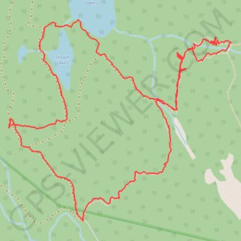
Import a GPX file

Showh Lakes

#Hiking #Loop

  • Distance: 4.5 mi
  • Elevation gain: 325 m
  • Maximum elevation: 1,048 m
  • Elevation loss: 324 m
  • Minimum elevation: 835 m

Interactive trail map

Trail profile

  • Distance: 4.5 mi
  • Elevation gain: 325 m
  • Maximum elevation: 1,048 m
  • Elevation loss: 324 m
  • Minimum elevation: 835 m

About this trail

Other hiking, mountain biking, running and outdoor activity trails

Click on a trail to view its statistics, map and profile.

Cheakamus River and Lillooet River

Canada > British Columbia > Squamish-Lillooet Regional District > Area D (Elaho/Garibaldi)

Bikepack from Daisy Lake along Cheakamus River and Lillooet River via Alta Lake, Whistler, Green Lake, Shadow Lake, Nairn Falls, One Mile Lake and Pemberton. #Bike #Nature #River #Lake #Mountain #Forest

Distance: 52.6 mi • Elevation gain: 1,233 m • Maximum elevation: 754 m

Vancouver - Golden

Canada > British Columbia > Metro Vancouver Regional District > Vancouver

#Bike #Vancouver #Golden

Distance: 514.2 mi • Elevation gain: 9,376 m • Maximum elevation: 1,347 m

Gear up for your next adventure:

🔦Outdoor Torches - Reliable torches for night navigation
🚶Walking Pedometers - Simple distance tracking for casual trail walkers
Lightweight Solo Tents - Backpacking tents designed for wild camping in the UK highlands
🛰️Satellite Messengers - Emergency communication devices for areas without mobile signal
🧢Waterproof Hiking Hats - Keep the rain off your face while studying topographic maps

As an Amazon Associate, this site earns from qualifying purchases at no extra cost to you.