Make a donation
Gear up for your next adventure:
As an Amazon Associate, this site earns from qualifying purchases at no extra cost to you.
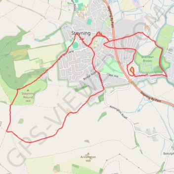
Steyning Bramber
- Distance: 7.3 mi
- Elevation gain: 238 m
- Maximum elevation: 180 m
- Elevation loss: 239 m
- Minimum elevation: 0 m
- Moving time: 2 h 36 m
- Moving speed: 2.8 mph
- Maximum speed: 5.0 mph
- Total time: 3 h 16 m
- Global speed: 2.2 mph
Interactive trail map
Make a donation
Gear up for your next adventure:
As an Amazon Associate, this site earns from qualifying purchases at no extra cost to you.
Trail profile
- Distance: 7.3 mi
- Elevation gain: 238 m
- Maximum elevation: 180 m
- Elevation loss: 239 m
- Minimum elevation: 0 m
- Moving time: 2 h 36 m
- Moving speed: 2.8 mph
- Maximum speed: 5.0 mph
- Total time: 3 h 16 m
- Global speed: 2.2 mph
Make a donation
Gear up for your next adventure:
As an Amazon Associate, this site earns from qualifying purchases at no extra cost to you.
About this trail
Name: Steyning Bramber trail, distance, elevation, map, profile, GPS track
Start: Bramber, Horsham, West Sussex, England, BN44 3WU, United Kingdom (50.88277 -0.31121)
End: The Street, Bramber, Horsham, West Sussex, England, BN44 3WE, United Kingdom (50.88319 -0.31204)
Coordinates: 50.87132 -0.35051 50.89043 -0.30652
Topography: West Sussex topographic map, elevation, terrain
Make a donation
Gear up for your next adventure:
As an Amazon Associate, this site earns from qualifying purchases at no extra cost to you.
Other hiking, mountain biking, running and outdoor activity trails
Click on a trail to view its statistics, map and profile.
Truleigh Hill and Mile Oak from Steyning and Beeding
United Kingdom > England > West Sussex > Steyning
Distance: 14.3 mi • Elevation gain: 494 m • Maximum elevation: 202 m
Bramber Castle
United Kingdom > England > West Sussex > Horsham > Bramber
Distance: 8.5 mi • Elevation gain: 260 m • Maximum elevation: 189 m