Thank you for supporting this site ❤️
Make a donation
Make a donation
Gear up for your next adventure:
As an Amazon Associate, this site earns from qualifying purchases at no extra cost to you.
Sugarloaf Scenic Reserve Loop
Interactive trail map
Thank you for supporting this site ❤️
Make a donation
Make a donation
Gear up for your next adventure:
As an Amazon Associate, this site earns from qualifying purchases at no extra cost to you.
Trail profile
- Distance: 3.0 mi
- Elevation gain: 321 m
- Maximum elevation: 456 m
- Elevation loss: 312 m
- Minimum elevation: 329 m
Thank you for supporting this site ❤️
Make a donation
Make a donation
Gear up for your next adventure:
As an Amazon Associate, this site earns from qualifying purchases at no extra cost to you.
About this trail
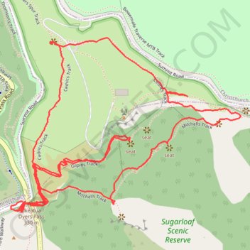
Name: Sugarloaf Scenic Reserve Loop trail, distance, elevation, map, profile, GPS track
Coordinates: -43.60658 172.64470 -43.60124 172.65447
Thank you for supporting this site ❤️
Make a donation
Make a donation
Gear up for your next adventure:
As an Amazon Associate, this site earns from qualifying purchases at no extra cost to you.
Other hiking, mountain biking, running and outdoor activity trails
Click on a trail to view its statistics, map and profile.
Halswell River
New Zealand > Canterbury > Christchurch City > Banks Peninsula Community
Distance: 42.8 mi • Elevation gain: 320 m • Maximum elevation: 40 m