Thank you for supporting this site ❤️
Make a donation
Make a donation
Gear up for your next adventure:
As an Amazon Associate, this site earns from qualifying purchases at no extra cost to you.
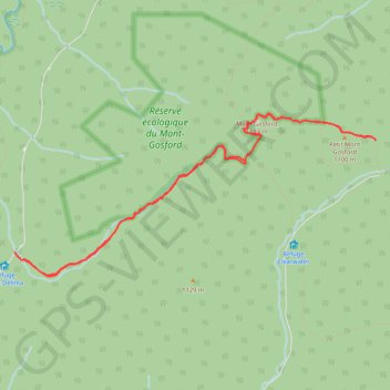
Mont Gosford - Petit Mont Gosford
Interactive trail map
Thank you for supporting this site ❤️
Make a donation
Make a donation
Gear up for your next adventure:
As an Amazon Associate, this site earns from qualifying purchases at no extra cost to you.
Trail profile
- Distance: 7.1 mi
- Elevation gain: 723 m
- Maximum elevation: 1,178 m
- Elevation loss: 720 m
- Minimum elevation: 668 m
Thank you for supporting this site ❤️
Make a donation
Make a donation
Gear up for your next adventure:
As an Amazon Associate, this site earns from qualifying purchases at no extra cost to you.
About this trail
Name: Mont Gosford - Petit Mont Gosford trail, distance, elevation, map, profile, GPS track
Start: Sentier Frontalier, Saint-Augustin-de-Woburn, Le Granit, Quebec, Canada (45.28872 -70.89954)
End: Sentier Frontalier, Saint-Augustin-de-Woburn, Le Granit, Quebec, Canada (45.28846 -70.89927)
Coordinates: 45.28644 -70.89954 45.30200 -70.85074
Thank you for supporting this site ❤️
Make a donation
Make a donation
Gear up for your next adventure:
As an Amazon Associate, this site earns from qualifying purchases at no extra cost to you.