Thank you for supporting this site ❤️
Make a donation
Make a donation
Gear up for your next adventure:
As an Amazon Associate, this site earns from qualifying purchases at no extra cost to you.
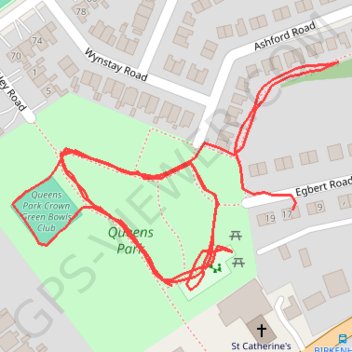
Queens Park Loop
- Distance: 1.0 mi
- Elevation gain: 7 m
- Maximum elevation: 13 m
- Elevation loss: 5 m
- Minimum elevation: 9 m
- Moving time: 23 m 11 s
- Moving speed: 2.5 mph
- Maximum speed: 3.9 mph
- Total time: 46 m 40 s
- Global speed: 1.2 mph
Interactive trail map
Thank you for supporting this site ❤️
Make a donation
Make a donation
Gear up for your next adventure:
As an Amazon Associate, this site earns from qualifying purchases at no extra cost to you.
Trail profile
- Distance: 1.0 mi
- Elevation gain: 7 m
- Maximum elevation: 13 m
- Elevation loss: 5 m
- Minimum elevation: 9 m
- Moving time: 23 m 11 s
- Moving speed: 2.5 mph
- Maximum speed: 3.9 mph
- Total time: 46 m 40 s
- Global speed: 1.2 mph
Thank you for supporting this site ❤️
Make a donation
Make a donation
Gear up for your next adventure:
As an Amazon Associate, this site earns from qualifying purchases at no extra cost to you.
About this trail
Name: Queens Park Loop trail, distance, elevation, map, profile, GPS track
Coordinates: 53.39910 -3.17206 53.40067 -3.16831
Topography: England topographic map, elevation, terrain
Thank you for supporting this site ❤️
Make a donation
Make a donation
Gear up for your next adventure:
As an Amazon Associate, this site earns from qualifying purchases at no extra cost to you.