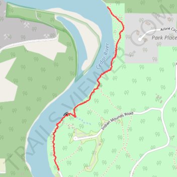
Palisades-Kepler State Park
- Distance: 1.1 mi
- Elevation gain: 50 m
- Maximum elevation: 244 m
- Elevation loss: 52 m
- Minimum elevation: 218 m
- Moving time: 35 m 15 s
- Moving speed: 1.8 mph
- Maximum speed: 3.8 mph
- Total time: 37 m 10 s
- Global speed: 1.7 mph
Interactive trail map
Trail profile
- Distance: 1.1 mi
- Elevation gain: 50 m
- Maximum elevation: 244 m
- Elevation loss: 52 m
- Minimum elevation: 218 m
- Moving time: 35 m 15 s
- Moving speed: 1.8 mph
- Maximum speed: 3.8 mph
- Total time: 37 m 10 s
- Global speed: 1.7 mph
About this trail
Name: Palisades-Kepler State Park trail, distance, elevation, map, profile, GPS track
Start: Cedar Cliff, Linn County, Iowa, United States (41.91785 -91.50773)
End: Cedar Cliff, Linn County, Iowa, United States (41.90658 -91.51227)
Coordinates: 41.90658 -91.51280 41.91785 -91.50624