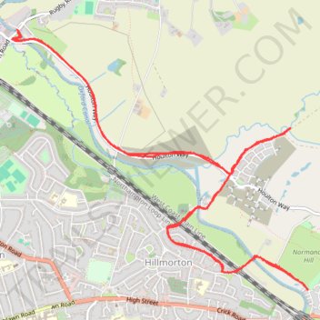
Moors Lane via Houlton Way
- Distance: 7.1 mi
- Elevation gain: 101 m
- Maximum elevation: 110 m
- Elevation loss: 99 m
- Minimum elevation: 90 m
- Moving time: 52 m 23 s
- Moving speed: 8.1 mph
- Maximum speed: 20.1 mph
- Total time: 55 m 39 s
- Global speed: 7.6 mph
Interactive trail map
Trail profile
- Distance: 7.1 mi
- Elevation gain: 101 m
- Maximum elevation: 110 m
- Elevation loss: 99 m
- Minimum elevation: 90 m
- Moving time: 52 m 23 s
- Moving speed: 8.1 mph
- Maximum speed: 20.1 mph
- Total time: 55 m 39 s
- Global speed: 7.6 mph
About this trail
Name: Moors Lane via Houlton Way trail, distance, elevation, map, profile, GPS track
Coordinates: 52.35909 -1.23544 52.37924 -1.19792
Topography: Warwickshire topographic map, elevation, terrain
Other hiking, mountain biking, running and outdoor activity trails
Click on a trail to view its statistics, map and profile.
The Jo Cox Way 2022 Day 3 Market Bosworth to Milton Keynes
United Kingdom > England > Leicestershire > Hinckley and Bosworth > Market Bosworth
Distance: 76.4 mi • Elevation gain: 953 m • Maximum elevation: 195 m