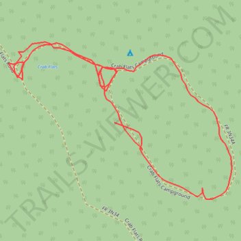
Crab Flats Family Campground
- Distance: 0.6 mi
- Elevation gain: 7 m
- Maximum elevation: 1,823 m
- Elevation loss: 8 m
- Minimum elevation: 1,815 m
- Moving time: 17 m 31 s
- Moving speed: 2.1 mph
- Maximum speed: 14.7 mph
- Total time: 17 m 31 s
- Global speed: 2.1 mph
Interactive trail map
Trail profile
- Distance: 0.6 mi
- Elevation gain: 7 m
- Maximum elevation: 1,823 m
- Elevation loss: 8 m
- Minimum elevation: 1,815 m
- Moving time: 17 m 31 s
- Moving speed: 2.1 mph
- Maximum speed: 14.7 mph
- Total time: 17 m 31 s
- Global speed: 2.1 mph
About this trail
Name: Crab Flats Family Campground trail, distance, elevation, map, profile, GPS track
Coordinates: 34.26204 -117.08688 34.26358 -117.08424