Thank you for supporting this site ❤️
Make a donation
Make a donation
Gear up for your next adventure:
As an Amazon Associate, this site earns from qualifying purchases at no extra cost to you.
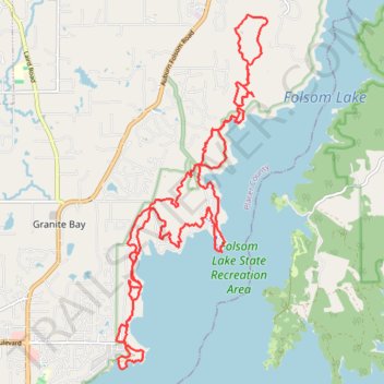
Long trail run in Folsom Lake State Recreation Area
- Distance: 17.7 mi
- Elevation gain: 463 m
- Maximum elevation: 225 m
- Elevation loss: 467 m
- Minimum elevation: 138 m
- Moving time: 4 h 23 m
- Moving speed: 4.0 mph
- Maximum speed: 11.5 mph
- Total time: 4 h 35 m
- Global speed: 3.9 mph
Interactive trail map
Thank you for supporting this site ❤️
Make a donation
Make a donation
Gear up for your next adventure:
As an Amazon Associate, this site earns from qualifying purchases at no extra cost to you.
Trail profile
- Distance: 17.7 mi
- Elevation gain: 463 m
- Maximum elevation: 225 m
- Elevation loss: 467 m
- Minimum elevation: 138 m
- Moving time: 4 h 23 m
- Moving speed: 4.0 mph
- Maximum speed: 11.5 mph
- Total time: 4 h 35 m
- Global speed: 3.9 mph
Thank you for supporting this site ❤️
Make a donation
Make a donation
Gear up for your next adventure:
As an Amazon Associate, this site earns from qualifying purchases at no extra cost to you.
About this trail
Name: Long trail run in Folsom Lake State Recreation Area trail, distance, elevation, map, profile, GPS track
Start: Park Road, Granite Bay, Placer County, California, United States (38.75055 -121.14780)
End: Park Road, Granite Bay, Placer County, California, United States (38.74761 -121.14839)
Coordinates: 38.73899 -121.15154 38.79812 -121.11920
Thank you for supporting this site ❤️
Make a donation
Make a donation
Gear up for your next adventure:
As an Amazon Associate, this site earns from qualifying purchases at no extra cost to you.