MTB Loop via Golden Fleece and Total Recall Trail in Peavine Mountain
- Distance: 19.7 mi
- Elevation gain: 918 m
- Maximum elevation: 2,015 m
- Elevation loss: 918 m
- Minimum elevation: 1,496 m
- Moving time: 2 h 31 m
- Moving speed: 7.8 mph
- Maximum speed: 23.8 mph
- Total time: 2 h 49 m
- Global speed: 6.9 mph
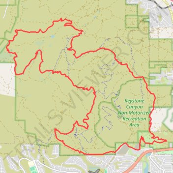
Interactive trail map
Trail profile
- Distance: 19.7 mi
- Elevation gain: 918 m
- Maximum elevation: 2,015 m
- Elevation loss: 918 m
- Minimum elevation: 1,496 m
- Moving time: 2 h 31 m
- Moving speed: 7.8 mph
- Maximum speed: 23.8 mph
- Total time: 2 h 49 m
- Global speed: 6.9 mph
About this trail
Name: MTB Loop via Golden Fleece and Total Recall Trail in Peavine Mountain trail, distance, elevation, map, profile, GPS track
Start: Keystone Canyon, Reno, Washoe County, Nevada, 89503, United States (39.55120 -119.84897)
End: Keystone Canyon, Reno, Washoe County, Nevada, 89503, United States (39.55124 -119.84895)
Coordinates: 39.54859 -119.90376 39.59173 -119.83800
Other hiking, mountain biking, running and outdoor activity trails
Click on a trail to view its statistics, map and profile.
Day 1: Home to dispersed camping 60 mi E of Austin, NV
United States > Nevada > Washoe County > Reno
Distance: 129.5 mi • Elevation gain: 1,012 m • Maximum elevation: 1,563 m