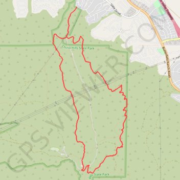
Bane Canyon Loop
Beginning near the North Entrance off Sapphire Road, the loop briefly follows Bane Canyon Road into Chino Hills State Park before leaving the paved corridor for the East Fence Line Trail, where rolling grasslands, coastal sage scrub, spring wildflowers, and views across Bane Canyon and the nearby urban edge appear in succession.
The route then follows the ridge spine through Pomona Trail and back onto East Fence Line Trail, winding past the park boundary fence, small gullies, chaparral-covered folds, and open slopes with broad looks toward distant ridgelines and Mount Baldy.
After passing toward Corral Trail and the equestrian staging area, the hike returns by Bane Ridge Trail above Bane Canyon Road, with canyon views, grass-covered hills, and oak- and sycamore-lined riparian pockets closing a classic ridge-and-valley circuit through Chino Hills State Park.
#Hiking #Loop #Canyon #Nature #Mountain #Park #Hills #Ridge
- Distance: 7.6 mi
- Elevation gain: 435 m
- Maximum elevation: 357 m
- Elevation loss: 434 m
- Minimum elevation: 214 m
Interactive trail map
Trail profile
- Distance: 7.6 mi
- Elevation gain: 435 m
- Maximum elevation: 357 m
- Elevation loss: 434 m
- Minimum elevation: 214 m
About this trail
Name: Bane Canyon Loop trail, distance, elevation, map, profile, GPS track
Coordinates: 33.91826 -117.70869 33.95468 -117.68918