Privdat1 délután
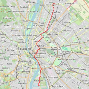
- Distance: 10.8 mi
- Elevation gain: 76 m
- Maximum elevation: 121 m
- Elevation loss: 65 m
- Minimum elevation: 97 m
- Moving time: 50 m 30 s
- Moving speed: 12.8 mph
- Maximum speed: 26.2 mph
- Total time: 51 m 55 s
- Global speed: 12.5 mph
Interactive trail map
Trail profile
- Distance: 10.8 mi
- Elevation gain: 76 m
- Maximum elevation: 121 m
- Elevation loss: 65 m
- Minimum elevation: 97 m
- Moving time: 50 m 30 s
- Moving speed: 12.8 mph
- Maximum speed: 26.2 mph
- Total time: 51 m 55 s
- Global speed: 12.5 mph
About this trail
Name: Privdat1 délután trail, distance, elevation, map, profile, GPS track
Coordinates: 47.44433 19.05858 47.56361 19.10419
Other hiking, mountain biking, running and outdoor activity trails
Click on a trail to view its statistics, map and profile.
Track_AECW_821_2023_11_27_2023_11_27_1701185001391
Distance: 102.2 mi • Elevation gain: 654 m • Maximum elevation: 244 m