Import a GPX file

Big Dalton Canyon Trail

Hike on the Big Dalton Canyon Trail in the Big Dalton Canyon Wilderness Park, the San Gabriel Mountains National Monument and the Angeles National Forest. #Hiking #Canyon #Mountain #Nature #Forest #Angeles
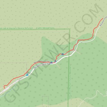
  • Distance: 1.0 mi
  • Elevation gain: 78 m
  • Maximum elevation: 439 m
  • Elevation loss: 14 m
  • Minimum elevation: 374 m

Interactive trail map

Trail profile

  • Distance: 1.0 mi
  • Elevation gain: 78 m
  • Maximum elevation: 439 m
  • Elevation loss: 14 m
  • Minimum elevation: 374 m

About this trail

Name: Big Dalton Canyon Trail trail, distance, elevation, map, profile, GPS track

Start: Mystic Canyon Trail, Glendora, Los Angeles County, California, 91741, United States (34.15873 -117.82856)

End: Big Dalton Canyon Road, Glendora, Los Angeles County, California, 91741, United States (34.16639 -117.81564)

Coordinates: 34.15873 -117.82866 34.16639 -117.81564

Gear up for your next adventure:

🔋Lithium AA Batteries - Long-lasting power that performs well in cold mountain weather
📍Handheld GPS Navigators - Reliable satellite navigation for hiking and off-road exploration
Insulated Travel Mugs - Keep drinks hot while surveying the landscape from a summit
🗺️Ordnance Survey Maps - Essential paper maps for hiking across the UK national parks
🌦️Portable Weather Meters - Handheld tools for monitoring weather conditions

As an Amazon Associate, this site earns from qualifying purchases at no extra cost to you.