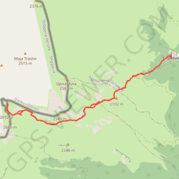
Golem Korab
- Distance: 11.1 mi
- Elevation gain: 1,382 m
- Maximum elevation: 2,728 m
- Elevation loss: 1,383 m
- Minimum elevation: 1,456 m
- Moving time: 6 h 11 m
- Moving speed: 1.8 mph
- Maximum speed: 9.4 mph
- Total time: 9 h 28 m
- Global speed: 1.2 mph
Interactive trail map
Trail profile
- Distance: 11.1 mi
- Elevation gain: 1,382 m
- Maximum elevation: 2,728 m
- Elevation loss: 1,383 m
- Minimum elevation: 1,456 m
- Moving time: 6 h 11 m
- Moving speed: 1.8 mph
- Maximum speed: 9.4 mph
- Total time: 9 h 28 m
- Global speed: 1.2 mph
About this trail
Name: Golem Korab trail, distance, elevation, map, profile, GPS track
Start: Strezimir, Brodec, Municipality of Gostivar, North Macedonia (41.80612 20.61848)
End: Strezimir, Brodec, Municipality of Gostivar, North Macedonia (41.80618 20.61858)
Coordinates: 41.78345 20.54657 41.80618 20.61889