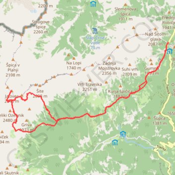
Julijski Alpi: od prevoja Vršić, Jalovška škrbina, Vratca v ...
- Distance: 11.2 mi
- Elevation gain: 2,080 m
- Maximum elevation: 2,598 m
- Elevation loss: 2,076 m
- Minimum elevation: 1,461 m
- Moving time: 8 h 24 m
- Moving speed: 1.3 mph
- Maximum speed: 3.1 mph
- Total time: 12 h 6 m
- Global speed: 0.9 mph
Interactive trail map
Trail profile
- Distance: 11.2 mi
- Elevation gain: 2,080 m
- Maximum elevation: 2,598 m
- Elevation loss: 2,076 m
- Minimum elevation: 1,461 m
- Moving time: 8 h 24 m
- Moving speed: 1.3 mph
- Maximum speed: 3.1 mph
- Total time: 12 h 6 m
- Global speed: 0.9 mph
About this trail
Name: Julijski Alpi: od prevoja Vršić, Jalovška škrbina, Vratca v ... trail, distance, elevation, map, profile, GPS track
Start: Vršiška cesta (Ruska cesta), Bovec, Slovenia (46.43503 13.74413)
End: Vršiška cesta (Ruska cesta), Bovec, Slovenia (46.43499 13.74428)
Coordinates: 46.40985 13.67803 46.43507 13.74428