Thank you for supporting this site ❤️
Make a donation
Make a donation
Gear up for your next adventure:
As an Amazon Associate, this site earns from qualifying purchases at no extra cost to you.
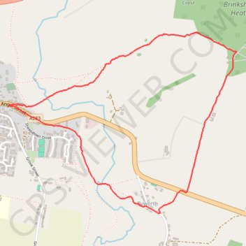
Petworth, Brinkshole Heath and Byworth loop
- Distance: 2.6 mi
- Elevation gain: 123 m
- Maximum elevation: 108 m
- Elevation loss: 123 m
- Minimum elevation: 22 m
- Moving time: 1 h 11 m
- Moving speed: 2.2 mph
- Maximum speed: 3.8 mph
- Total time: 1 h 12 m
- Global speed: 2.2 mph
Interactive trail map
Thank you for supporting this site ❤️
Make a donation
Make a donation
Gear up for your next adventure:
As an Amazon Associate, this site earns from qualifying purchases at no extra cost to you.
Trail profile
- Distance: 2.6 mi
- Elevation gain: 123 m
- Maximum elevation: 108 m
- Elevation loss: 123 m
- Minimum elevation: 22 m
- Moving time: 1 h 11 m
- Moving speed: 2.2 mph
- Maximum speed: 3.8 mph
- Total time: 1 h 12 m
- Global speed: 2.2 mph
Thank you for supporting this site ❤️
Make a donation
Make a donation
Gear up for your next adventure:
As an Amazon Associate, this site earns from qualifying purchases at no extra cost to you.
About this trail
Name: Petworth, Brinkshole Heath and Byworth loop trail, distance, elevation, map, profile, GPS track
Coordinates: 50.97992 -0.60738 50.99014 -0.58695
Topography: Chichester topographic map, elevation, terrain
Thank you for supporting this site ❤️
Make a donation
Make a donation
Gear up for your next adventure:
As an Amazon Associate, this site earns from qualifying purchases at no extra cost to you.