Import a GPX file

Cascade Falls Trail

  • Distance: 0.7 mi
  • Elevation gain: 22 m
  • Maximum elevation: 2,111 m
  • Elevation loss: 58 m
  • Minimum elevation: 2,070 m

Interactive trail map

Trail profile

  • Distance: 0.7 mi
  • Elevation gain: 22 m
  • Maximum elevation: 2,111 m
  • Elevation loss: 58 m
  • Minimum elevation: 2,070 m

About this trail

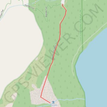
Name: Cascade Falls Trail trail, distance, elevation, map, profile, GPS track

Start: Bayview Trailhead Parking, Bayview Trail, El Dorado County, California, United States (38.94354 -120.09991)

End: Cascade Falls Trails, El Dorado County, California, United States (38.93479 -120.10130)

Coordinates: 38.93479 -120.10238 38.94354 -120.09950

Gear up for your next adventure:

🌦️Portable Weather Meters - Handheld tools for monitoring weather conditions
🥾Hiking Boot Waterproofing Wax - Maintain the lifespan of your leather trekking boots
🧴Sport Sunscreen Sticks - High-protection sunblock that won't run into your eyes on the trail
🧥Packable Down Jackets - Lightweight warmth that compresses small in your bag
📷Camera Straps - Secure straps for carrying cameras while walking

As an Amazon Associate, this site earns from qualifying purchases at no extra cost to you.