Tmp
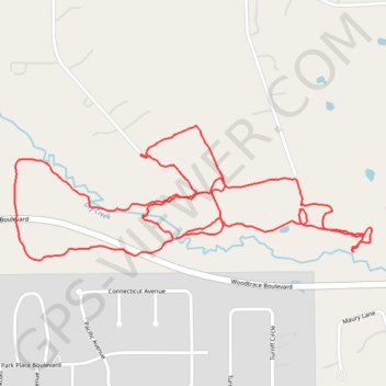
- Distance: 2.8 mi
- Elevation gain: 22 m
- Maximum elevation: 55 m
- Elevation loss: 22 m
- Minimum elevation: 47 m
- Moving time: 50 m 56 s
- Moving speed: 3.3 mph
- Maximum speed: 6.1 mph
- Total time: 50 m 56 s
- Global speed: 3.3 mph
Interactive trail map
Trail profile
- Distance: 2.8 mi
- Elevation gain: 22 m
- Maximum elevation: 55 m
- Elevation loss: 22 m
- Minimum elevation: 47 m
- Moving time: 50 m 56 s
- Moving speed: 3.3 mph
- Maximum speed: 6.1 mph
- Total time: 50 m 56 s
- Global speed: 3.3 mph
About this trail
Name: Tmp trail, distance, elevation, map, profile, GPS track
Start: 30800, Chelsie Place, Montgomery County, Texas, 77354, United States (30.19469 -95.61647)
End: 30800, Chelsie Place, Montgomery County, Texas, 77354, United States (30.19469 -95.61647)
Coordinates: 30.19180 -95.62047 30.19546 -95.60917