Thank you for supporting this site ❤️
Make a donation
Make a donation
Gear up for your next adventure:
As an Amazon Associate, this site earns from qualifying purchases at no extra cost to you.
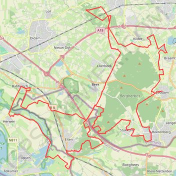
Outdoor Achterhoek - Montferland 71 km
- Distance: 44.1 mi
- Elevation gain: 305 m
- Maximum elevation: 81 m
- Elevation loss: 306 m
- Minimum elevation: 10 m
- Moving time: 5 h 35 m
- Moving speed: 7.9 mph
- Maximum speed: 15.1 mph
- Total time: 5 h 35 m
- Global speed: 7.9 mph
Interactive trail map
Thank you for supporting this site ❤️
Make a donation
Make a donation
Gear up for your next adventure:
As an Amazon Associate, this site earns from qualifying purchases at no extra cost to you.
Trail profile
- Distance: 44.1 mi
- Elevation gain: 305 m
- Maximum elevation: 81 m
- Elevation loss: 306 m
- Minimum elevation: 10 m
- Moving time: 5 h 35 m
- Moving speed: 7.9 mph
- Maximum speed: 15.1 mph
- Total time: 5 h 35 m
- Global speed: 7.9 mph
Thank you for supporting this site ❤️
Make a donation
Make a donation
Gear up for your next adventure:
As an Amazon Associate, this site earns from qualifying purchases at no extra cost to you.
About this trail
Name: Outdoor Achterhoek - Montferland 71 km trail, distance, elevation, map, profile, GPS track
Coordinates: 51.85413 6.10040 51.95695 6.26301
Thank you for supporting this site ❤️
Make a donation
Make a donation
Gear up for your next adventure:
As an Amazon Associate, this site earns from qualifying purchases at no extra cost to you.
Other hiking, mountain biking, running and outdoor activity trails
Click on a trail to view its statistics, map and profile.
Eurovelo 15 - Strasbourg Rotterdam
France > Grand Est > Bas-Rhin > Strasbourg
Distance: 554.1 mi • Elevation gain: 2,104 m • Maximum elevation: 146 m