Thank you for supporting this site ❤️
Make a donation
Make a donation
Gear up for your next adventure:
As an Amazon Associate, this site earns from qualifying purchases at no extra cost to you.
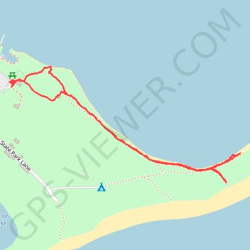
St. Andrews State Park
- Distance: 1.3 mi
- Elevation gain: 12 m
- Maximum elevation: 9 m
- Elevation loss: 12 m
- Minimum elevation: 0 m
- Moving time: 40 m 56 s
- Moving speed: 1.9 mph
- Maximum speed: 9.3 mph
- Total time: 43 m 36 s
- Global speed: 1.8 mph
Interactive trail map
Thank you for supporting this site ❤️
Make a donation
Make a donation
Gear up for your next adventure:
As an Amazon Associate, this site earns from qualifying purchases at no extra cost to you.
Trail profile
- Distance: 1.3 mi
- Elevation gain: 12 m
- Maximum elevation: 9 m
- Elevation loss: 12 m
- Minimum elevation: 0 m
- Moving time: 40 m 56 s
- Moving speed: 1.9 mph
- Maximum speed: 9.3 mph
- Total time: 43 m 36 s
- Global speed: 1.8 mph
Thank you for supporting this site ❤️
Make a donation
Make a donation
Gear up for your next adventure:
As an Amazon Associate, this site earns from qualifying purchases at no extra cost to you.
About this trail
Name: St. Andrews State Park trail, distance, elevation, map, profile, GPS track
Start: Campers Drive, Bay County, Florida, 32411, United States (30.13199 -85.73105)
End: Campers Drive, Bay County, Florida, 32411, United States (30.13189 -85.73095)
Coordinates: 30.12896 -85.73105 30.13245 -85.72303
Thank you for supporting this site ❤️
Make a donation
Make a donation
Gear up for your next adventure:
As an Amazon Associate, this site earns from qualifying purchases at no extra cost to you.