Import a GPX file

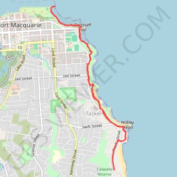
Port Macquarie Coastal Walk

#Hiking #Macquarie

  • Distance: 5.2 mi
  • Elevation gain: 182 m
  • Maximum elevation: 36 m
  • Elevation loss: 171 m
  • Minimum elevation: 0 m
  • Moving time: 1 h 20 m
  • Moving speed: 3.9 mph
  • Maximum speed: 34.0 mph
  • Total time: 1 h 22 m
  • Global speed: 3.8 mph

Interactive trail map

Trail profile

  • Distance: 5.2 mi
  • Elevation gain: 182 m
  • Maximum elevation: 36 m
  • Elevation loss: 171 m
  • Minimum elevation: 0 m
  • Moving time: 1 h 20 m
  • Moving speed: 3.9 mph
  • Maximum speed: 34.0 mph
  • Total time: 1 h 22 m
  • Global speed: 3.8 mph

About this trail

Gear up for your next adventure:

🔋Solar Chargers - Eco-friendly charging solutions for outdoor use
🧢Waterproof Hiking Hats - Keep the rain off your face while studying topographic maps
👖Convertible Hiking Trousers - Versatile zip-off pants for changing mountain weather conditions
💧Hydration Reservoirs - Convenient water bladders for hands-free drinking on the move
🎒Hiking Child Carriers - Explore the outdoors with the whole family safely

As an Amazon Associate, this site earns from qualifying purchases at no extra cost to you.