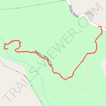
Waihou Spring Trail
- Distance: 0.9 mi
- Elevation gain: 134 m
- Maximum elevation: 1,163 m
- Elevation loss: 34 m
- Minimum elevation: 1,028 m
- Moving time: 32 m 31 s
- Moving speed: 1.6 mph
- Maximum speed: 5.0 mph
- Total time: 42 m 45 s
- Global speed: 1.2 mph
Interactive trail map
Trail profile
- Distance: 0.9 mi
- Elevation gain: 134 m
- Maximum elevation: 1,163 m
- Elevation loss: 34 m
- Minimum elevation: 1,028 m
- Moving time: 32 m 31 s
- Moving speed: 1.6 mph
- Maximum speed: 5.0 mph
- Total time: 42 m 45 s
- Global speed: 1.2 mph
About this trail
Name: Waihou Spring Trail trail, distance, elevation, map, profile, GPS track
Start: Waihau Spring Trail, Maui County, Hawaii, United States (20.80463 -156.28647)
End: 2419, Olinda Road, Maui County, Hawaii, 96768, United States (20.80615 -156.27998)
Coordinates: 20.80255 -156.28676 20.80615 -156.27969