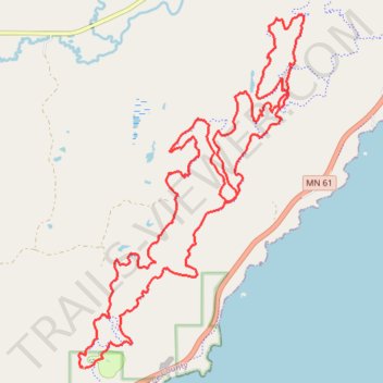
Split Rock Wilds
- Distance: 16.7 mi
- Elevation gain: 445 m
- Maximum elevation: 397 m
- Elevation loss: 446 m
- Minimum elevation: 246 m
- Moving time: 2 h 37 m
- Moving speed: 6.4 mph
- Maximum speed: 20.0 mph
- Total time: 2 h 58 m
- Global speed: 5.6 mph
Interactive trail map
Trail profile
- Distance: 16.7 mi
- Elevation gain: 445 m
- Maximum elevation: 397 m
- Elevation loss: 446 m
- Minimum elevation: 246 m
- Moving time: 2 h 37 m
- Moving speed: 6.4 mph
- Maximum speed: 20.0 mph
- Total time: 2 h 58 m
- Global speed: 5.6 mph
About this trail
Name: Split Rock Wilds trail, distance, elevation, map, profile, GPS track
Start: Shipwreck Loop, Beaver Bay Township, Lake County, Minnesota, United States (47.20728 -91.38077)
End: Shipwreck Loop, Beaver Bay Township, Lake County, Minnesota, United States (47.20731 -91.38057)
Coordinates: 47.20726 -91.38172 47.25530 -91.33670