Thank you for supporting this site ❤️
Make a donation
Make a donation
Gear up for your next adventure:
As an Amazon Associate, this site earns from qualifying purchases at no extra cost to you.
The Spinneys
- Distance: 1.0 mi
- Elevation gain: 8 m
- Maximum elevation: 8 m
- Elevation loss: 8 m
- Minimum elevation: 0 m
- Moving time: 41 m 2 s
- Moving speed: 1.5 mph
- Maximum speed: 3.0 mph
- Total time: 1 h 10 m
- Global speed: 0.9 mph
Interactive trail map
Thank you for supporting this site ❤️
Make a donation
Make a donation
Gear up for your next adventure:
As an Amazon Associate, this site earns from qualifying purchases at no extra cost to you.
Trail profile
- Distance: 1.0 mi
- Elevation gain: 8 m
- Maximum elevation: 8 m
- Elevation loss: 8 m
- Minimum elevation: 0 m
- Moving time: 41 m 2 s
- Moving speed: 1.5 mph
- Maximum speed: 3.0 mph
- Total time: 1 h 10 m
- Global speed: 0.9 mph
Thank you for supporting this site ❤️
Make a donation
Make a donation
Gear up for your next adventure:
As an Amazon Associate, this site earns from qualifying purchases at no extra cost to you.
About this trail
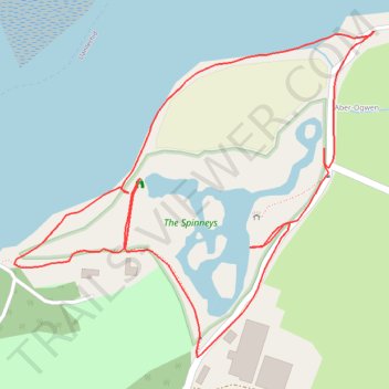
Name: The Spinneys trail, distance, elevation, map, profile, GPS track
Start: Aber-Ogwen, Llanllechid, Tal-y-bont, Gwynedd, Wales, LL57 3YH, United Kingdom (53.23046 -4.07611)
End: Aber-Ogwen, Llanllechid, Tal-y-bont, Gwynedd, Wales, LL57 3YH, United Kingdom (53.23046 -4.07609)
Coordinates: 53.22713 -4.08223 53.23046 -4.07609
Topography: Gwynedd topographic map, elevation, terrain
Thank you for supporting this site ❤️
Make a donation
Make a donation
Gear up for your next adventure:
As an Amazon Associate, this site earns from qualifying purchases at no extra cost to you.