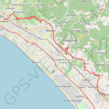
VFS - IT25 - Avenza - Pietrasanta
- Distance: 18.1 mi
- Elevation gain: 812 m
- Maximum elevation: 229 m
- Elevation loss: 799 m
- Minimum elevation: 9 m
Interactive trail map
Trail profile
- Distance: 18.1 mi
- Elevation gain: 812 m
- Maximum elevation: 229 m
- Elevation loss: 799 m
- Minimum elevation: 9 m
About this trail
Name: VFS - IT25 - Avenza - Pietrasanta trail, distance, elevation, map, profile, GPS track
Start: Via Gino Menconi, Avenza, Carrara, Massa-Carrara, Tuscany, 54033, Italy (44.04685 10.06230)
Coordinates: 43.95712 10.06230 44.05646 10.23172
Other hiking, mountain biking, running and outdoor activity trails
Click on a trail to view its statistics, map and profile.
1 LUCENA - MONTPELLIER
Distance: 1,842.0 mi • Elevation gain: 29,500 m • Maximum elevation: 1,048 m