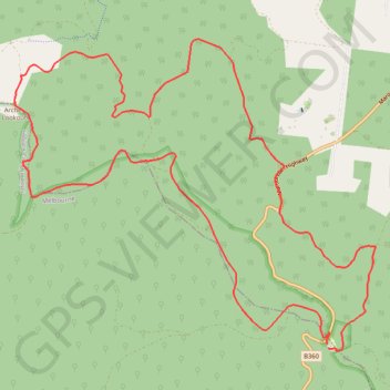
Import a GPX file

Monda Track

Yarra Ranges National Park. #Hiking #Loop #Yarra

  • Distance: 10.8 mi
  • Elevation gain: 754 m
  • Maximum elevation: 942 m
  • Elevation loss: 751 m
  • Minimum elevation: 365 m

Interactive trail map

Trail profile

  • Distance: 10.8 mi
  • Elevation gain: 754 m
  • Maximum elevation: 942 m
  • Elevation loss: 751 m
  • Minimum elevation: 365 m

About this trail

Other hiking, mountain biking, running and outdoor activity trails

Click on a trail to view its statistics, map and profile.

Tallarook - Eildon - Hurstbridge

Australia > Victoria > Tallarook

#Bike

Distance: 173.2 mi • Elevation gain: 4,897 m • Maximum elevation: 868 m

Gear up for your next adventure:

🧗Locking Carabiners - Secure gear to your pack or for light technical use
🧴Sport Sunscreen Sticks - High-protection sunblock that won't run into your eyes on the trail
🎒Replacement Sternum Straps - Repair parts for hiking rucksacks
🪓Outdoor Multitools - Versatile tools for hiking and camping
🔦LED Camping Lanterns - Illumination for reading maps inside your tent at night

As an Amazon Associate, this site earns from qualifying purchases at no extra cost to you.