
Blois - amboise MAP 2
- Distance: 26.1 mi
- Elevation gain: 252 m
- Maximum elevation: 111 m
- Elevation loss: 261 m
- Minimum elevation: 57 m
- Moving time: 3 h 29 m
- Moving speed: 7.5 mph
- Maximum speed: 8.2 mph
- Total time: 3 h 29 m
- Global speed: 7.5 mph
Interactive trail map
Trail profile
- Distance: 26.1 mi
- Elevation gain: 252 m
- Maximum elevation: 111 m
- Elevation loss: 261 m
- Minimum elevation: 57 m
- Moving time: 3 h 29 m
- Moving speed: 7.5 mph
- Maximum speed: 8.2 mph
- Total time: 3 h 29 m
- Global speed: 7.5 mph
About this trail
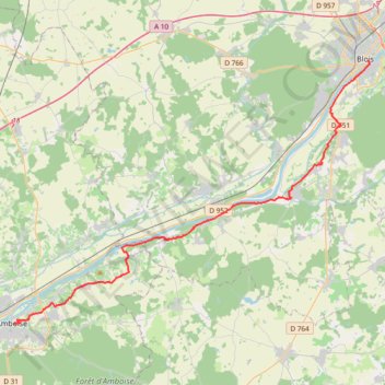
Name: Blois - amboise MAP 2 trail, distance, elevation, map, profile, GPS track
Coordinates: 47.41023 0.98656 47.58601 1.33889
Other hiking, mountain biking, running and outdoor activity trails
Click on a trail to view its statistics, map and profile.

La Loire à Vélo
France > Pays de la Loire > Loire-Atlantique > Saint-Brevin-les-Pins
Distance: 408.8 mi • Elevation gain: 2,492 m • Maximum elevation: 186 m
GR 654 - Le chemin vers Saint-Jacques-de-Compostelle via Vézelay
France > Nouvelle-Aquitaine > Dordogne > Bergerac
Distance: 503.8 mi • Elevation gain: 9,631 m • Maximum elevation: 670 m