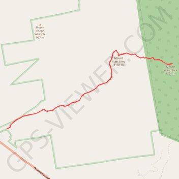
Mount Waumbek and Mount Starr King
Hike to Mount Waumbek and Mount Starr King via Starr King Trail and Kilkenny Ridge Trail in the White Mountain National Forest. #Hiking #Mountain #Nature #Forest
- Distance: 6.7 mi
- Elevation gain: 819 m
- Maximum elevation: 1,208 m
- Elevation loss: 820 m
- Minimum elevation: 484 m
- Moving time: 3 h 5 m
- Moving speed: 2.2 mph
- Maximum speed: 3.4 mph
- Total time: 3 h 24 m
- Global speed: 2.0 mph
Interactive trail map
Trail profile
- Distance: 6.7 mi
- Elevation gain: 819 m
- Maximum elevation: 1,208 m
- Elevation loss: 820 m
- Minimum elevation: 484 m
- Moving time: 3 h 5 m
- Moving speed: 2.2 mph
- Maximum speed: 3.4 mph
- Total time: 3 h 24 m
- Global speed: 2.0 mph
About this trail
Name: Mount Waumbek and Mount Starr King trail, distance, elevation, map, profile, GPS track
Start: Starr King Trail, Jefferson, Coös County, New Hampshire, 03583, United States (44.41850 -71.46678)
End: Starr King Trail, Jefferson, Coös County, New Hampshire, 03583, United States (44.41848 -71.46682)
Coordinates: 44.41848 -71.46682 44.43556 -71.41646
Other hiking, mountain biking, running and outdoor activity trails
Click on a trail to view its statistics, map and profile.