Thank you for supporting this site ❤️
Make a donation
Make a donation
Gear up for your next adventure:
As an Amazon Associate, this site earns from qualifying purchases at no extra cost to you.
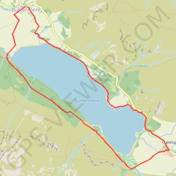
Buttermere - Lake District National Park
Interactive trail map
Thank you for supporting this site ❤️
Make a donation
Make a donation
Gear up for your next adventure:
As an Amazon Associate, this site earns from qualifying purchases at no extra cost to you.
Trail profile
- Distance: 4.3 mi
- Elevation gain: 126 m
- Maximum elevation: 154 m
- Elevation loss: 129 m
- Minimum elevation: 102 m
Thank you for supporting this site ❤️
Make a donation
Make a donation
Gear up for your next adventure:
As an Amazon Associate, this site earns from qualifying purchases at no extra cost to you.
About this trail
Name: Buttermere - Lake District National Park trail, distance, elevation, map, profile, GPS track
Start: B5289, Buttermere, Cumberland, England, CA13 9UZ, United Kingdom (54.54131 -3.27599)
End: B5289, Buttermere, Cumberland, England, CA13 9UZ, United Kingdom (54.54131 -3.27635)
Coordinates: 54.52159 -3.28019 54.54131 -3.24633
Topography: Cumberland topographic map, elevation, terrain
Thank you for supporting this site ❤️
Make a donation
Make a donation
Gear up for your next adventure:
As an Amazon Associate, this site earns from qualifying purchases at no extra cost to you.