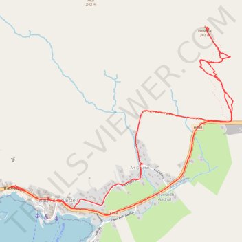
Heaval hike
- Distance: 4.1 mi
- Elevation gain: 385 m
- Maximum elevation: 369 m
- Elevation loss: 385 m
- Minimum elevation: 5 m
- Moving time: 1 h 58 m
- Moving speed: 2.1 mph
- Maximum speed: 6.0 mph
- Total time: 4 h 8 m
- Global speed: 1.0 mph
Interactive trail map
Trail profile
- Distance: 4.1 mi
- Elevation gain: 385 m
- Maximum elevation: 369 m
- Elevation loss: 385 m
- Minimum elevation: 5 m
- Moving time: 1 h 58 m
- Moving speed: 2.1 mph
- Maximum speed: 6.0 mph
- Total time: 4 h 8 m
- Global speed: 1.0 mph
About this trail
Name: Heaval hike trail, distance, elevation, map, profile, GPS track
Start: The Square, Ledaig, Castlebay, Western Isles, Scotland, HS9 5XD, United Kingdom (56.95602 -7.49146)
End: The Square, Ledaig, Castlebay, Western Isles, Scotland, HS9 5XD, United Kingdom (56.95593 -7.49182)
Coordinates: 56.95415 -7.49182 56.96630 -7.46529
Topography: Western Isles topographic map, elevation, terrain