Thank you for supporting this site ❤️
Make a donation
Make a donation
Gear up for your next adventure:
As an Amazon Associate, this site earns from qualifying purchases at no extra cost to you.
Holly State Recreation Area
Interactive trail map
Thank you for supporting this site ❤️
Make a donation
Make a donation
Gear up for your next adventure:
As an Amazon Associate, this site earns from qualifying purchases at no extra cost to you.
Trail profile
- Distance: 2.3 mi
- Elevation gain: 36 m
- Maximum elevation: 334 m
- Elevation loss: 35 m
- Minimum elevation: 320 m
- Moving time: 1 h 18 m
- Moving speed: 1.8 mph
- Maximum speed: 3.3 mph
- Total time: 1 h 20 m
- Global speed: 1.7 mph
Thank you for supporting this site ❤️
Make a donation
Make a donation
Gear up for your next adventure:
As an Amazon Associate, this site earns from qualifying purchases at no extra cost to you.
About this trail
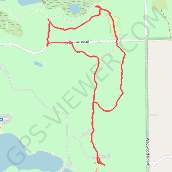
Name: Holly State Recreation Area trail, distance, elevation, map, profile, GPS track
Start: Wildwood Road, Austin Corners, Oakland County, Michigan, 48442, United States (42.80999 -83.51519)
End: Wildwood Road, Austin Corners, Oakland County, Michigan, 48442, United States (42.80886 -83.51453)
Coordinates: 42.80830 -83.51929 42.81914 -83.51207
Thank you for supporting this site ❤️
Make a donation
Make a donation
Gear up for your next adventure:
As an Amazon Associate, this site earns from qualifying purchases at no extra cost to you.