Gorton Lower Reservoir Loop
- Distance: 1.3 mi
- Elevation gain: 21 m
- Maximum elevation: 87 m
- Elevation loss: 25 m
- Minimum elevation: 75 m
- Moving time: 31 m 36 s
- Moving speed: 2.4 mph
- Maximum speed: 3.7 mph
- Total time: 33 m 29 s
- Global speed: 2.3 mph
Interactive trail map
Trail profile
- Distance: 1.3 mi
- Elevation gain: 21 m
- Maximum elevation: 87 m
- Elevation loss: 25 m
- Minimum elevation: 75 m
- Moving time: 31 m 36 s
- Moving speed: 2.4 mph
- Maximum speed: 3.7 mph
- Total time: 33 m 29 s
- Global speed: 2.3 mph
About this trail
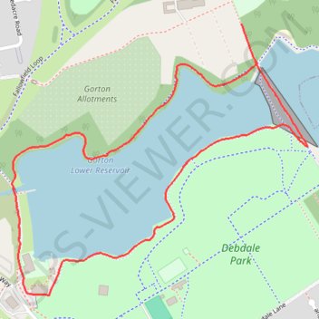
Name: Gorton Lower Reservoir Loop trail, distance, elevation, map, profile, GPS track
Coordinates: 53.45944 -2.16146 53.46433 -2.15252
Topography: Manchester topographic map, elevation, terrain
Other hiking, mountain biking, running and outdoor activity trails
Click on a trail to view its statistics, map and profile.
Morning Run
United Kingdom > England > Manchester
Distance: 6.5 mi • Elevation gain: 54 m • Maximum elevation: 99 m
Gorton Parks Loop
United Kingdom > England > Manchester
Distance: 1.7 mi • Elevation gain: 15 m • Maximum elevation: 88 m
Gorton Loop
United Kingdom > England > Manchester
Distance: 6.1 mi • Elevation gain: 53 m • Maximum elevation: 100 m
Southern shoreline path of Gorton Lower Reservoir
United Kingdom > England > Manchester
Distance: 0.6 mi • Elevation gain: 16 m • Maximum elevation: 82 m
Wright Robinson Loop
United Kingdom > England > Manchester
Distance: 1.2 mi • Elevation gain: 14 m • Maximum elevation: 91 m
Debdale Park
United Kingdom > England > Manchester
Distance: 1.3 mi • Elevation gain: 27 m • Maximum elevation: 88 m