Thank you for supporting this site ❤️
Make a donation
Make a donation
Gear up for your next adventure:
As an Amazon Associate, this site earns from qualifying purchases at no extra cost to you.
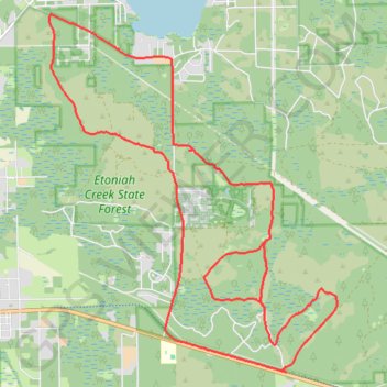
Etoniah Creek State Forest Loop
Bike
- Distance: 19.0 mi
- Elevation gain: 179 m
- Maximum elevation: 55 m
- Elevation loss: 179 m
- Minimum elevation: 22 m
- Moving time: 1 h 44 m
- Moving speed: 10.9 mph
- Maximum speed: 23.0 mph
- Total time: 3 h 18 m
- Global speed: 5.7 mph
Interactive trail map
Thank you for supporting this site ❤️
Make a donation
Make a donation
Gear up for your next adventure:
As an Amazon Associate, this site earns from qualifying purchases at no extra cost to you.
Trail profile
- Distance: 19.0 mi
- Elevation gain: 179 m
- Maximum elevation: 55 m
- Elevation loss: 179 m
- Minimum elevation: 22 m
- Moving time: 1 h 44 m
- Moving speed: 10.9 mph
- Maximum speed: 23.0 mph
- Total time: 3 h 18 m
- Global speed: 5.7 mph
Thank you for supporting this site ❤️
Make a donation
Make a donation
Gear up for your next adventure:
As an Amazon Associate, this site earns from qualifying purchases at no extra cost to you.
About this trail
Name: Etoniah Creek State Forest Loop trail, distance, elevation, map, profile, GPS track
Start: East V Road, Baywood, Putnam County, Florida, United States (29.72201 -81.82358)
End: Putnam County, Florida, 32140, United States (29.72215 -81.82377)
Coordinates: 29.72165 -81.87300 29.78707 -81.81235
Thank you for supporting this site ❤️
Make a donation
Make a donation
Gear up for your next adventure:
As an Amazon Associate, this site earns from qualifying purchases at no extra cost to you.