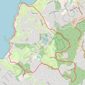
Green Loop in the Del Monte Forest trail network
From the Pebble Beach Equestrian Center, the Green Loop offers a broad circuit through Del Monte Forest, passing wooded hills and canyon-like forest areas before reaching Spanish Bay, dunes, rocky Pacific shoreline, Bird Rock Park, and the golf-course edges on the way back.
#Hiking #Loop #Forest #Cost #Pacific #Nature
- Distance: 10.8 mi
- Elevation gain: 310 m
- Maximum elevation: 209 m
- Elevation loss: 310 m
- Minimum elevation: 0 m
- Moving time: 2 h 7 m
- Moving speed: 5.1 mph
- Maximum speed: 10.1 mph
- Total time: 2 h 12 m
- Global speed: 4.9 mph
Interactive trail map
Trail profile
- Distance: 10.8 mi
- Elevation gain: 310 m
- Maximum elevation: 209 m
- Elevation loss: 310 m
- Minimum elevation: 0 m
- Moving time: 2 h 7 m
- Moving speed: 5.1 mph
- Maximum speed: 10.1 mph
- Total time: 2 h 12 m
- Global speed: 4.9 mph
About this trail
Name: Green Loop in the Del Monte Forest trail network trail, distance, elevation, map, profile, GPS track
Coordinates: 36.57126 -121.96497 36.60978 -121.92388