Chickasaw State Park Hiking Trail
- Distance: 2.5 mi
- Elevation gain: 59 m
- Maximum elevation: 188 m
- Elevation loss: 58 m
- Minimum elevation: 153 m
- Moving time: 1 h 10 m
- Moving speed: 2.2 mph
- Maximum speed: 4.0 mph
- Total time: 1 h 20 m
- Global speed: 1.9 mph
Interactive trail map
Trail profile
- Distance: 2.5 mi
- Elevation gain: 59 m
- Maximum elevation: 188 m
- Elevation loss: 58 m
- Minimum elevation: 153 m
- Moving time: 1 h 10 m
- Moving speed: 2.2 mph
- Maximum speed: 4.0 mph
- Total time: 1 h 20 m
- Global speed: 1.9 mph
About this trail
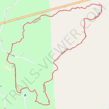
Name: Chickasaw State Park Hiking Trail trail, distance, elevation, map, profile, GPS track
Start: Hiking Trail, Chester County, West Tennessee, Tennessee, United States (35.39245 -88.77040)
End: Hiking Trail, Chester County, West Tennessee, Tennessee, United States (35.39254 -88.77045)
Coordinates: 35.38668 -88.77105 35.39634 -88.75994
Other hiking, mountain biking, running and outdoor activity trails
Click on a trail to view its statistics, map and profile.
Gmaps Pedometer Route
United States > Kentucky > Fulton County > Hickman
Distance: 312.5 mi • Elevation gain: 4,204 m • Maximum elevation: 592 m