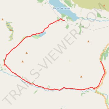
Old Wade Road near Sma Glen
- Distance: 10.4 mi
- Elevation gain: 312 m
- Maximum elevation: 449 m
- Elevation loss: 337 m
- Minimum elevation: 219 m
- Moving time: 3 h 49 m
- Moving speed: 2.7 mph
- Maximum speed: 8.8 mph
- Total time: 5 h 7 m
- Global speed: 2.0 mph
Interactive trail map
Trail profile
- Distance: 10.4 mi
- Elevation gain: 312 m
- Maximum elevation: 449 m
- Elevation loss: 337 m
- Minimum elevation: 219 m
- Moving time: 3 h 49 m
- Moving speed: 2.7 mph
- Maximum speed: 8.8 mph
- Total time: 5 h 7 m
- Global speed: 2.0 mph
About this trail
Name: Old Wade Road near Sma Glen trail, distance, elevation, map, profile, GPS track
End: Perth and Kinross, Scotland, PH8 0DA, United Kingdom (56.50968 -3.84455)
Coordinates: 56.46345 -3.91705 56.51079 -3.79606
Topography: Perth and Kinross topographic map, elevation, terrain
Other hiking, mountain biking, running and outdoor activity trails
Click on a trail to view its statistics, map and profile.
Exploring the building ruins of Craignavar township
United Kingdom > Scotland > Perth and Kinross
Distance: 2.0 mi • Elevation gain: 106 m • Maximum elevation: 289 m