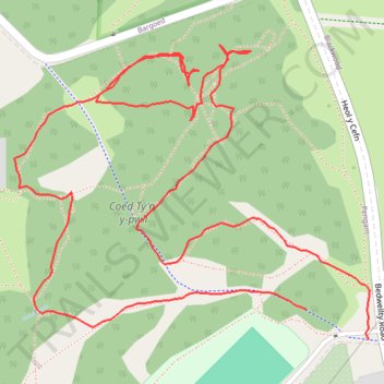
Blackwood Woodland - Coed Ty'n-y-pwll loop
- Distance: 1.2 mi
- Elevation gain: 52 m
- Maximum elevation: 225 m
- Elevation loss: 55 m
- Minimum elevation: 192 m
- Moving time: 31 m 23 s
- Moving speed: 2.2 mph
- Maximum speed: 3.6 mph
- Total time: 32 m 39 s
- Global speed: 2.1 mph
Interactive trail map
Trail profile
- Distance: 1.2 mi
- Elevation gain: 52 m
- Maximum elevation: 225 m
- Elevation loss: 55 m
- Minimum elevation: 192 m
- Moving time: 31 m 23 s
- Moving speed: 2.2 mph
- Maximum speed: 3.6 mph
- Total time: 32 m 39 s
- Global speed: 2.1 mph
About this trail
Name: Blackwood Woodland - Coed Ty'n-y-pwll loop trail, distance, elevation, map, profile, GPS track
Coordinates: 51.67669 -3.21592 51.67940 -3.21066
Topography: Caerphilly County Borough topographic map, elevation, terrain
Other hiking, mountain biking, running and outdoor activity trails
Click on a trail to view its statistics, map and profile.
The Headstock 500
United Kingdom > Wales > Newport > Newport
Distance: 300.4 mi • Elevation gain: 9,616 m • Maximum elevation: 691 m