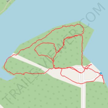
Mogador Reservoir
- Distance: 1.6 mi
- Elevation gain: 43 m
- Maximum elevation: 345 m
- Elevation loss: 43 m
- Minimum elevation: 331 m
- Moving time: 53 m 44 s
- Moving speed: 1.8 mph
- Maximum speed: 3.4 mph
- Total time: 57 m 1 s
- Global speed: 1.7 mph
Interactive trail map
Trail profile
- Distance: 1.6 mi
- Elevation gain: 43 m
- Maximum elevation: 345 m
- Elevation loss: 43 m
- Minimum elevation: 331 m
- Moving time: 53 m 44 s
- Moving speed: 1.8 mph
- Maximum speed: 3.4 mph
- Total time: 57 m 1 s
- Global speed: 1.7 mph
About this trail
Name: Mogador Reservoir trail, distance, elevation, map, profile, GPS track
Start: Ticknor Road, Suffield Township, Portage County, Ohio, 44260, United States (41.06065 -81.36858)
End: Ticknor Road, Suffield Township, Portage County, Ohio, 44260, United States (41.06059 -81.36869)
Coordinates: 41.06011 -81.37318 41.06270 -81.36743