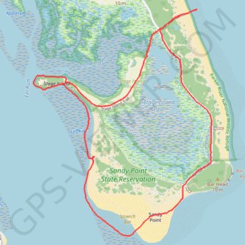
Sandy Point Loop, Newbury / Plum Island, MA
- Distance: 3.6 mi
- Elevation gain: 26 m
- Maximum elevation: 7 m
- Elevation loss: 26 m
- Minimum elevation: -1 m
- Moving time: 1 h 34 m
- Moving speed: 2.3 mph
- Maximum speed: 3.3 mph
- Total time: 1 h 43 m
- Global speed: 2.1 mph
Interactive trail map
Trail profile
- Distance: 3.6 mi
- Elevation gain: 26 m
- Maximum elevation: 7 m
- Elevation loss: 26 m
- Minimum elevation: -1 m
- Moving time: 1 h 34 m
- Moving speed: 2.3 mph
- Maximum speed: 3.3 mph
- Total time: 1 h 43 m
- Global speed: 2.1 mph
About this trail
Name: Sandy Point Loop, Newbury / Plum Island, MA trail, distance, elevation, map, profile, GPS track
Start: Lot 6 Boardwalk, Ipswich, Essex County, Massachusetts, United States (42.71392 -70.77785)
End: Lot 6 Boardwalk, Ipswich, Essex County, Massachusetts, United States (42.71388 -70.77786)
Coordinates: 42.70017 -70.78930 42.71526 -70.77317