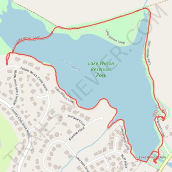
Lake Wilson Loop Trail
- Distance: 2.3 mi
- Elevation gain: 38 m
- Maximum elevation: 47 m
- Elevation loss: 38 m
- Minimum elevation: 34 m
- Moving time: 43 m 57 s
- Moving speed: 3.2 mph
- Maximum speed: 5.0 mph
- Total time: 47 m 53 s
- Global speed: 2.9 mph
Interactive trail map
Trail profile
- Distance: 2.3 mi
- Elevation gain: 38 m
- Maximum elevation: 47 m
- Elevation loss: 38 m
- Minimum elevation: 34 m
- Moving time: 43 m 57 s
- Moving speed: 3.2 mph
- Maximum speed: 5.0 mph
- Total time: 47 m 53 s
- Global speed: 2.9 mph
About this trail
Name: Lake Wilson Loop Trail trail, distance, elevation, map, profile, GPS track
Start: Lake Wilson Loop, Wilson, Wilson County, North Carolina, United States (35.78851 -77.92019)
End: Lake Wilson Loop, Wilson, Wilson County, North Carolina, United States (35.78854 -77.92020)
Coordinates: 35.78851 -77.92976 35.79657 -77.91957
Other hiking, mountain biking, running and outdoor activity trails
Click on a trail to view its statistics, map and profile.
Afternoon hike at Lake Wilson Loop Trail
United States > North Carolina > Wilson County > Wilson
Wilson Lake
Distance: 2.5 mi • Elevation gain: 36 m • Maximum elevation: 44 m