Thank you for supporting this site ❤️
Make a donation
Make a donation
Gear up for your next adventure:
As an Amazon Associate, this site earns from qualifying purchases at no extra cost to you.
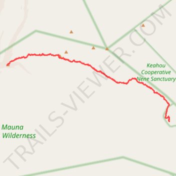
Mauna Loa's 2022 Lava Flow from Lookout by Red Hill Cabin
- Distance: 22.4 mi
- Elevation gain: 1,443 m
- Maximum elevation: 3,363 m
- Elevation loss: 1,445 m
- Minimum elevation: 1,936 m
- Moving time: 8 h 39 m
- Moving speed: 2.6 mph
- Maximum speed: 9.6 mph
- Total time: 10 h 18 m
- Global speed: 2.2 mph
Interactive trail map
Thank you for supporting this site ❤️
Make a donation
Make a donation
Gear up for your next adventure:
As an Amazon Associate, this site earns from qualifying purchases at no extra cost to you.
Trail profile
- Distance: 22.4 mi
- Elevation gain: 1,443 m
- Maximum elevation: 3,363 m
- Elevation loss: 1,445 m
- Minimum elevation: 1,936 m
- Moving time: 8 h 39 m
- Moving speed: 2.6 mph
- Maximum speed: 9.6 mph
- Total time: 10 h 18 m
- Global speed: 2.2 mph
Thank you for supporting this site ❤️
Make a donation
Make a donation
Gear up for your next adventure:
As an Amazon Associate, this site earns from qualifying purchases at no extra cost to you.
About this trail
Name: Mauna Loa's 2022 Lava Flow from Lookout by Red Hill Cabin trail, distance, elevation, map, profile, GPS track
Start: Mauna Loa Road, Volcano, Hawaiʻi County, Hawaii, United States (19.48498 -155.38357)
End: Mauna Loa Road, Volcano, Hawaiʻi County, Hawaii, United States (19.48475 -155.38351)
Coordinates: 19.48475 -155.50262 19.53152 -155.38344
Thank you for supporting this site ❤️
Make a donation
Make a donation
Gear up for your next adventure:
As an Amazon Associate, this site earns from qualifying purchases at no extra cost to you.