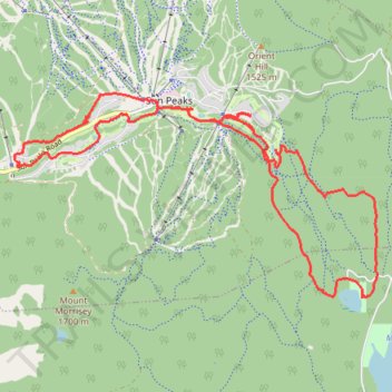
Sun Peaks Nordic Backcountry Ski Trails
- Distance: 11.2 mi
- Elevation gain: 368 m
- Maximum elevation: 1,443 m
- Elevation loss: 369 m
- Minimum elevation: 1,200 m
- Moving time: 2 h 27 m
- Moving speed: 4.6 mph
- Maximum speed: 21.9 mph
- Total time: 2 h 34 m
- Global speed: 4.4 mph
Interactive trail map
Trail profile
- Distance: 11.2 mi
- Elevation gain: 368 m
- Maximum elevation: 1,443 m
- Elevation loss: 369 m
- Minimum elevation: 1,200 m
- Moving time: 2 h 27 m
- Moving speed: 4.6 mph
- Maximum speed: 21.9 mph
- Total time: 2 h 34 m
- Global speed: 4.4 mph
About this trail
Name: Sun Peaks Nordic Backcountry Ski Trails trail, distance, elevation, map, profile, GPS track
Coordinates: 50.86019 -119.91203 50.88524 -119.84210
Other hiking, mountain biking, running and outdoor activity trails
Click on a trail to view its statistics, map and profile.
Mount Morrisey Backcountry Ski trails
Canada > British Columbia > Thompson-Nicola Regional District > Area P (Rivers and the Peaks)
Got a little off route at top of fisher and on bruin romp
Distance: 6.1 mi • Elevation gain: 50 m • Maximum elevation: 1,644 m