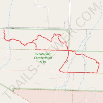
Bicentennial Conservation Area Loop Hike
- Distance: 3.6 mi
- Elevation gain: 93 m
- Maximum elevation: 379 m
- Elevation loss: 94 m
- Minimum elevation: 342 m
- Moving time: 1 h 36 m
- Moving speed: 2.2 mph
- Maximum speed: 6.4 mph
- Total time: 1 h 55 m
- Global speed: 1.9 mph
Interactive trail map
Trail profile
- Distance: 3.6 mi
- Elevation gain: 93 m
- Maximum elevation: 379 m
- Elevation loss: 94 m
- Minimum elevation: 342 m
- Moving time: 1 h 36 m
- Moving speed: 2.2 mph
- Maximum speed: 6.4 mph
- Total time: 1 h 55 m
- Global speed: 1.9 mph
About this trail
Name: Bicentennial Conservation Area Loop Hike trail, distance, elevation, map, profile, GPS track
Start: Landis Road, Neosho, Newton County, Missouri, 64850, United States (36.84223 -94.35123)
End: Landis Road, Neosho, Newton County, Missouri, 64850, United States (36.84276 -94.35127)
Coordinates: 36.83543 -94.35128 36.84276 -94.33128