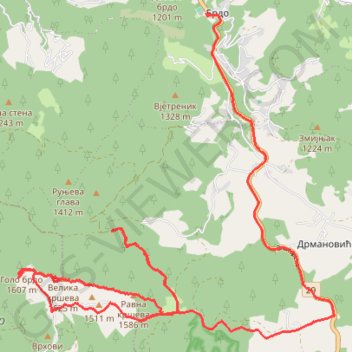
Trenutna trasa: 07 KOL 2018 11:37
- Distance: 14.4 mi
- Elevation gain: 784 m
- Maximum elevation: 1,612 m
- Elevation loss: 530 m
- Minimum elevation: 1,138 m
- Moving time: 3 h 53 m
- Moving speed: 3.7 mph
- Maximum speed: 35.4 mph
- Total time: 4 h 26 m
- Global speed: 3.2 mph
Interactive trail map
Trail profile
- Distance: 14.4 mi
- Elevation gain: 784 m
- Maximum elevation: 1,612 m
- Elevation loss: 530 m
- Minimum elevation: 1,138 m
- Moving time: 3 h 53 m
- Moving speed: 3.7 mph
- Maximum speed: 35.4 mph
- Total time: 4 h 26 m
- Global speed: 3.2 mph
About this trail
Name: Trenutna trasa: 07 KOL 2018 11:37 trail, distance, elevation, map, profile, GPS track
Coordinates: 43.40136 19.78140 43.44816 19.84408
Other hiking, mountain biking, running and outdoor activity trails
Click on a trail to view its statistics, map and profile.
2022_Yu
Slovenia > Ajdovščina > Žapuže
Distance: 1,526.9 mi • Elevation gain: 32,048 m • Maximum elevation: 1,950 m