Thank you for supporting this site ❤️
Make a donation
Make a donation
Gear up for your next adventure:
As an Amazon Associate, this site earns from qualifying purchases at no extra cost to you.
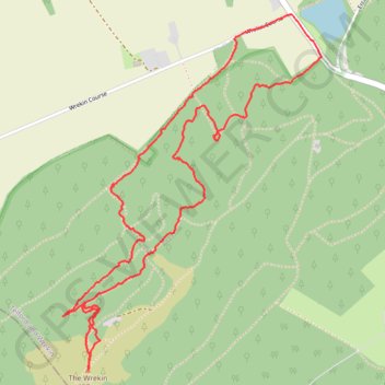
Some of the lesser know routes up the Wrekin
Wrekin alternative - Shropshire Hills National Landscape
- Distance: 3.2 mi
- Elevation gain: 302 m
- Maximum elevation: 402 m
- Elevation loss: 302 m
- Minimum elevation: 150 m
- Moving time: 1 h 27 m
- Moving speed: 2.2 mph
- Maximum speed: 6.5 mph
- Total time: 1 h 40 m
- Global speed: 1.9 mph
Interactive trail map
Thank you for supporting this site ❤️
Make a donation
Make a donation
Gear up for your next adventure:
As an Amazon Associate, this site earns from qualifying purchases at no extra cost to you.
Trail profile
- Distance: 3.2 mi
- Elevation gain: 302 m
- Maximum elevation: 402 m
- Elevation loss: 302 m
- Minimum elevation: 150 m
- Moving time: 1 h 27 m
- Moving speed: 2.2 mph
- Maximum speed: 6.5 mph
- Total time: 1 h 40 m
- Global speed: 1.9 mph
Thank you for supporting this site ❤️
Make a donation
Make a donation
Gear up for your next adventure:
As an Amazon Associate, this site earns from qualifying purchases at no extra cost to you.
About this trail
Name: Some of the lesser know routes up the Wrekin trail, distance, elevation, map, profile, GPS track
Coordinates: 52.66928 -2.55293 52.68184 -2.53778
Topography: Telford and Wrekin topographic map, elevation, terrain
Thank you for supporting this site ❤️
Make a donation
Make a donation
Gear up for your next adventure:
As an Amazon Associate, this site earns from qualifying purchases at no extra cost to you.