Fletcher Canyon
Hike to Fletcher Canyon from Kyle Canyon Road via the Fletcher Canyon Trail in Mount Charleston Wilderness. #Hiking #Canyon #Mountain #Nature #Forest #Wilderness
- Distance: 1.7 mi
- Elevation gain: 287 m
- Maximum elevation: 2,401 m
- Elevation loss: 18 m
- Minimum elevation: 2,125 m
- Moving time: 44 m 9 s
- Moving speed: 2.3 mph
- Maximum speed: 4.3 mph
- Total time: 54 m 13 s
- Global speed: 1.9 mph
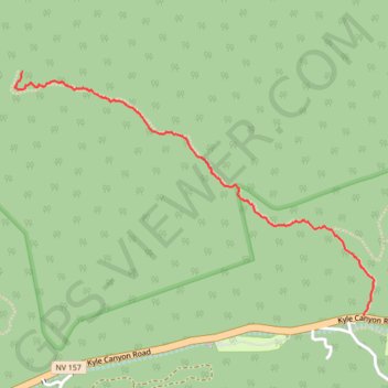
Interactive trail map
Trail profile
- Distance: 1.7 mi
- Elevation gain: 287 m
- Maximum elevation: 2,401 m
- Elevation loss: 18 m
- Minimum elevation: 2,125 m
- Moving time: 44 m 9 s
- Moving speed: 2.3 mph
- Maximum speed: 4.3 mph
- Total time: 54 m 13 s
- Global speed: 1.9 mph
About this trail
Name: Fletcher Canyon trail, distance, elevation, map, profile, GPS track
Start: Kyle Canyon Road, Mount Charleston, Clark County, Nevada, United States (36.26349 -115.61175)
End: Fletcher Canyon Trail, Mount Charleston, Clark County, Nevada, United States (36.27449 -115.63084)
Coordinates: 36.26349 -115.63129 36.27449 -115.61119