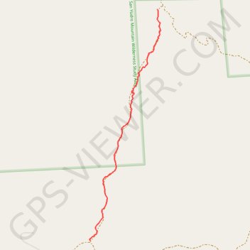
San Ysidro Mountain Wilderness
#Hiking #Mountain #Wilderness #Nature
- Distance: 0.8 mi
- Elevation gain: 5 m
- Maximum elevation: 1,506 m
- Elevation loss: 130 m
- Minimum elevation: 1,380 m
- Moving time: 27 m 26 s
- Moving speed: 1.8 mph
- Maximum speed: 3.6 mph
- Total time: 33 m 12 s
- Global speed: 1.5 mph
Interactive trail map
Trail profile
- Distance: 0.8 mi
- Elevation gain: 5 m
- Maximum elevation: 1,506 m
- Elevation loss: 130 m
- Minimum elevation: 1,380 m
- Moving time: 27 m 26 s
- Moving speed: 1.8 mph
- Maximum speed: 3.6 mph
- Total time: 33 m 12 s
- Global speed: 1.5 mph
About this trail
Name: San Ysidro Mountain Wilderness trail, distance, elevation, map, profile, GPS track
Start: San Diego County, California, United States (33.24555 -116.50787)
End: Via Oak Grove Lane, San Diego County, California, 92066, United States (33.23575 -116.51126)
Coordinates: 33.23574 -116.51131 33.24555 -116.50771